Sunday, 25 May 2014

Day 86: Uphall to Falkirk


An enjoyable but not inspiring days walk. We are currently heading West North West to get around the Firth of Forth and get to the start of the West Highland Way but are making headway in our trek through Scotland with the blue dot marking our current position.


The day started out damp and very misty as we headed along the road North out of Uphall. As we climbed the mist became more dense and as we did not need to navigate using physical landmarks we could enjoy being wrapped in the misty cloak, warm and snug in our wet weather gear.


As we entered the Beecraigs forest and country park, the mist began to lift and we could enjoy the splendour of the magnificent trees, which were so tall I could hardly crane my neck enough to see the tips.


Coming over the rise from Beecraigs we followed a park path down the hill and into Linlithgow,


where we joined the Union Canal, which we then followed for the 14 or so Km to our destination.


We followed it over the Avon Aqueduct which, according to Wikipedia is 810 feet long and 81 feet high.


The hight of the aqueduct made the view breathtaking but the 2 dimensional photo cannot do it justice.


As we neared Falkirk we followed the canal through Prospect Hill along the 690 feet tunnel. It was quite dark and we could hear the bats squeaking as we walked... A very enjoyable part of the walk. Canal tow path walking is OK but the predictability can be a bit monotonous. However, once we reach the Highlands I will probably be longing for another towpath (never happy)!


Saturday, 24 May 2014

Day 85: West Linton to Uphall

Starting out from the village, we again followed the Cross Boarders Drove Road, which follows the route that for more than 200 years was used to drove cattle down from the Highlands to English markets. Today, once again we began with a constant uphill walk that was just steep enough to be interesting but not too taxing. Initially the path was a paved lane,


which turned into a footpath and soon left the gentle landscape behind to become open moorland


inhabited by hill sheep and beautiful highland cattle... So gentle!


The day was damp, misty and mizzlling but very pleasant, and as we climbed, the views through the mist were stunning.


Our route followed "Thieve's Road", so named because robbers and cattle reivers would hide along this section of the cattle route to relieve the drovers of their charges.


Walking the track, I could well imagine the nervousness of those early drovers as they drove their cattle through the mist as the scene across the moors was both mystical and mistical (not that there is such a word).


Theive's Road goes over Cauldstane Slap, which is the name of the pass between East Cairn and West Cairn Hills and is at an elevation of about 440mtr.


and after reaching the pass we began our descent to the valley below. At this point the path became increasingly boggy but not too challenging and the views offset any discomfort.


Thieves Road ended at Little Vantage and from there we had a few Km of road walking through tamer rural land until we reached East Calder,


and were able to pick up a footpath which we followed over the River Almond and on to our destination. A most enjoyable day of walking!


Friday, 23 May 2014

Day 84: Peebles to a West Linton

A lovely, easy walk today! Short in distance, about 20 km, and just enough climbing to stop being too boring. After a quiet stroll through the town we joined the Cross Boarders Drove Road,


and started a reasonably steep climb up Hamilton Hill, stopping half way to enjoy the view back down toward Peebles nestled below next to the River Tweed.

 
Looking down over Eddleston Water we could see the alternate way to West  Linton that we followed on our last long walk. Peebles and West Linton are two of very few spots that we have duplicated on this walk.


The day was cool and the air filed with the sweet, coconut scent of the gorse, which always seems to be more fragrant in Scotland.


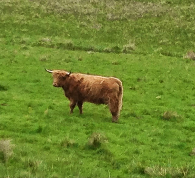
This fine beast was one of several grazing in a field and looked so friendly I had to take its photo as we continued on through a lovely rural landscape,


but, as always those hills are ever present on the skyline.


Although the lighting does not show it off to good advantage, this old barn looked so picturesque as we started to climb through the fields,


and up through a cool, peaceful forest, which, tho' the climb was steep, was pleasant and very quiet.


As we came up over the top of the saddle between Craitzie Hill and Ewe Hill we left the forest and followed the contours around over open hill land with the hardy hill sheep and their lambs grazing and softly calling to each other and their offspring.


Continuing along the side of the hill, following Fingland Burn, we soon found ourselves dropping down toward Lynwater, and the little town of West Linton, our destination for the day, was visible in the distance.


Day 83: Hartleap to Peebles

What an exhilarating day! It was rainy and misty but somehow that just seemed right for the terrain: wild and for the most part, uninhibited. We had detoured from our original plan to seak accommodation at Hartleap, a beautiful B&B which nestled comfortably in its environment. Mein Hosts were knowledgable about the area and gave us advice about how to navigate our way back to the Southern Upland Way by heading out from the back door of their property, so to speak, and following the wee burn in a roughly NE direction following the contours for a way.


W


As can be seen from the map, we climbed slowly accross the contours up Moory Haas, and heading toward Altrieve Burn., then around Moory Hass to follow the direction of the burn, gradually climbing higher towards Peat Law. Then as we reached a point where we could cross the Burn, we scrambled down and across, to gradually move around and up Altrieve Rig, heading for the lowest point ( the saddle) between Altrieve Rigg and White Law. As we climbed, the views were spectacular and not done justice by my little phone camera.


On reaching our highest point, we could see, through the mist and to our left, the edge of St Mary's Loch,


and to our right, shrouded in the mist, the glen and Yarrow Water.


We descended down the slope towards the 5km mark of our original to cross the bridge at the bottom.


Before crossing the bridge we crossed farmland and in so doing needed to open a very old and rickety gate. Oh dear, as we went to close it one of the metal brackets holding the structure, simply fell out of its holes. We put it back as best we could and, spying the farmer in the next field, crossed to let her know what had happened. She smiled and said... "Did you hit it with a rock from the wall?" Feeling very self righteous, we assured her that we had not. "Well you should've, that's what I would have done" she replied with a grin. Oh well, you can't win them all! 


After crossing the bridge we were back on track on the Southern Upland Way, and for a while it was a gentle walk up a gradually steepening track, through farmland... Back to gate and style country!


The views of course were wonderful, 


and for a short while the terrain was relatively flat as we left the Southern Upland Way and followed Douglas Burn.


But all good things must come to an end and we left the glen to turn up a forest track, climbing steadily uphill between Bught Rig and Brakehope Rig.


Leaving the track to follow an ildefined footpath, the way became steadily more challenging, more boggy and more beautifull, as we gazed (well that was my excuse for stopping) back across the hillside.


We finally left the bog and trees behind as we reached Whiteknowe Head,


and again paused to soak in the wild beauty of the countryside... Breathtaking!


Forsaking the signposted route, we opted to head down a virtual path that like so many others, existed only on a map, in the sands ( or mud) of time, or in someone's imagination. But definitely not on the ground! We followed Douglas Burn down to the Glen, bumping over grassy tufts, squelching through soggy grass, sinking deeply into the heather, and thoroughly enjoying ourselves (at least in retrospect) and finally reached the glen below. Pausing to look back up from whence we had come,


and forward to the future, we followed an increasingly civilised path, all the way into Peebles. The rain eventually stopped and we arrived at our destination, tired but feeling very satisfied.


Wednesday, 21 May 2014

Day 82: Samye-Ling Tibetan Centre to Hartleap

Wheeeew! What a day, it was certainly propitious that we walked further yesterday because today's walk was a doozie. It started of fine with a road walk climbing gently up through Eskdalemuir Forest with views out across remote farming land,


and across to the distant hills.


We then left the road and followed a farm track down to Glendeargh Burn which we followed on the near side for a short distance before we had to wade across. After I had changed my sox from water coming over the top of my boots we continued on what, on the map, was a clear track, but on the ground was rough, boggy ground.


That was only the beginning of our woes. The track never did eventuate and as we followed the burn up the glen, the ground became even more rough, boggy and steep!


On one side was the burn, and on the other, thick, impenitent able forest: so little room for manoeuvre.


The going was Tough! and I was really struggling: legs tired, head pounding (no coffe at the Buddist place) and lungs bursting. Then this...


it was almost too much, I just cried... There was just nothing else to do... If there had been a bus stop, I'd have hopped on a bus and headed for Heathrow and the first plane home! But there wasn't and I couldn't so there was nothing else to do but push on. Over a barbed wire fence (that's Keith protecting the family jewels as he strides over)


As always, all bad things come to an end and we reached a logging track and were able to at last enjoy the stunning scenery as we followed it down 


and down toward the road where we could join the Southern Upland trail and a more navigable track.


I even had time to checkout the very new additions to the local flock... this little fellow still had the dried remains of its umbilical cord attached.


The gentle stroll down the lane ended as we turned up the side of Scabcleuch Hill and puffed our way along the side of the stunning Glen. This time we did have the energy to enjoy the scenery, and stunning it was! 


The rest of the walk through the Forrest was uneventful and we arrived at our B& B in good time and good spirits.